To Follow Click The Blue Button

Showing posts with label National Geographic. Show all posts

Monday, October 3, 2022

National Geographic


The National Geographic Resource Library has tons of high-quality, standards-based, educational resources and activities. Resources include maps, lesson plans, interactive activities, and reference materials. You can search the resource collection by resource type, subject area or grade level. To see the website click here.

If you used an idea from this website then buy Mr H a gatorade :)  Thank you

Wednesday, September 18, 2019

Map Maker Interactive

Just like scribble maps I posted about before (click here) National Geographic MapMaker Interactive is a digital map making tool.  To see how to use it watch the following video but watch it in the Youtube site and on the right hand side are plenty of other tutorials.  Map Maker Interactive can be found by clicking here.


Wednesday, November 28, 2018

Common Geographic Misconceptions


logo 
The National Geographic has a nice article online titled, "Why Your Mental Map Of The World Is (Probably) Wrong".  According to their article, "These are some of the most common geographic misconceptions that are both surprising and surprisingly hard to correct."    For example, "Most of Africa is north of the equator, though on many mental maps it is mostly in the southern hemisphere directly across the Atlantic from South America."  To see the article click here.
Glen Weibe suggests asking these questions:
Based on your mental (or actual) map of the world, answer a few simple questions:
How much of South America is east of Miami, Florida?
How much of Africa is north of the equator?
Which city is further north – Paris, France or Montreal, Canada?
Venice, Italy is located at the same latitude of what major American city?
Which is bigger? The lower 48 United States or Brazil?

Glen suggests having your students use "The True Size Of" website for the last question.  I have blogged about this map website in March of 2017.  To see that post click here.

He also suggests Bouncy Maps which  "connect locations with data. Maps become bigger or smaller to show differences in the data."  To see Bouncy Maps, click here.

Monday, November 5, 2018

iNaturalist


I was reading Larry Ferlazzo's blog and he mentioned Inaturalist.  With this app you and your students can take a picture of something in nature like a Monarch butterfly and with some information about where and when you took the picture etc, you and your students will be able to contribute to a real world science project.

From the Inaturalist website, "One of the world’s most popular nature apps, iNaturalist helps you identify the plants and animals around you. Get connected with a community of over 750,000 scientists and naturalists who can help you learn more about nature! What’s more, by recording and sharing your observations, you’ll create research quality data for scientists working to better understand and protect nature. iNaturalist is a joint initiative by the California Academy of Sciences and the National Geographic Society."

Here is a link to the teachers guide and you can click here to the page on getting started.  If you happen to be taking your class out on a field trip, this might be a great activity to do in conjunction with your trip.  See the video below.


Wednesday, March 7, 2018

National Geographic Mapmaker Kit

National Geographic
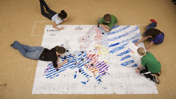
If you would like some large maps for your classroom that you can printout on regular 8x11 paper and jigsaw them together then try National Geographic Mapmaker Kit.  According to their website,"Each kit enables the user to download, print, and assemble maps of the world, individual continents, and the United States in a variety of sizes. Mega maps occupy a large wall, or can be used on the floor; projector maps give you some flexibility about sizing; the tabletop map is good for small group work, and the one-page outline maps are perfect for individual work."

To see the website click here.

Monday, October 2, 2017

Today I Learned


These videos on this site are all short.  According to National Geographic, "Learn something extraordinary!  National Geographic explorers tell you new, obscure, and amazing things about the world (and beyond)."  To see their website click here.


Friday, December 9, 2016

Grosvenor Teacher Fellow Program

Image result for national geographic icon
From Richard Byrne, The Grosvenor Teacher Fellow Program is now taking applications from US and Canadian teachers interested in field work expeditions to places around the globe.  The entry deadline is the end of this month.  To see the entry information click here.
The 2016 Class of Fellows

Wednesday, November 23, 2016

National Geographic MapMaker


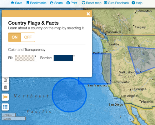
If you need a map making tool, you might want to try MapMaker by National Geographic.  To see the website  click here.  You might need a tutorial on how to use this in your classroom.  To see some tutorials click here.  There are new interactive  tools on MapMaker since these tutorials were made.  Namely, Country Facts and Flags, Latitude and Longitude, Custom text, photos and videos.
mapmaker-flags

Wednesday, November 9, 2016

Oil Pipeline through British Columbia


If you are teaching Current Events or Geography in Canada, the National Geographic Society has some lessons and activities on the proposed oil pipeline through British Columbia.  To see the lessons click here.

Whale tail in British Columbia

Friday, November 15, 2013

Geography Awareness Week

National Geographic - Education
Geography Awareness Week is November 17 -23 and you can check out National Geographic's website by clicking here.  They have also archived their Geographic Awareness Week material going back to 2000.  You can see that by clicking here.  

Here are some activities that I have posted about in the past:
Geosense - posted on November 19 2012 - click here.
Overlap Maps - posted on December 5 2012 - click here.
Creatively Simple Ways to Teach Geography - posted on March 6 2013 - click here.
Mission Map Quest - posted on April 17 2013 - click here.
GeoGuessr - posted on November 13 2013 - click here.